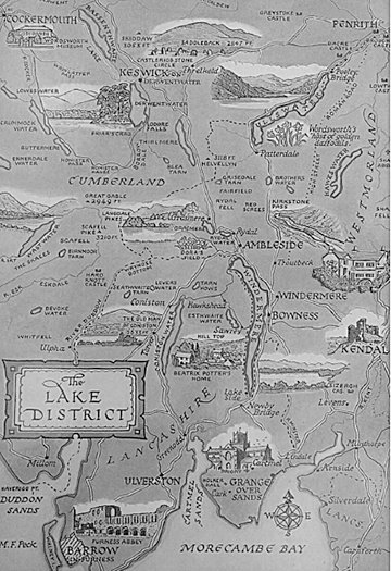
My wife and I were in London and decided we would go on a walking tour of the English countryside. Our criteria was quite basic – the walking shouldn’t kill us and there should be good pubs and bed and breakfast places at the end of the day. It did not take us long to decide on a circular tour of the Lakeland district.
This was not exactly an original decision on our part. The earliest visitors to the area were hunter-gatherers of the Middle Stone Age period, some 8,000 years ago. Somewhat later the Beaker people arrived in Lakeland. The Beakers are best known for Stonehenge and other standing stone sites. Coming along in their tum were the Celts, the Romans, the Angles and the Saxons, the Vikings and finally, the Scots. Each of the invaders left their mark on Lakeland either physically in the form of Roman forts or in place names as in the case of the Vikings.
The attraction of Lakeland, at least for modern visitors, lies in its beauty as well as its history. In all, there are 14 lakes radiating out from Langdale. Formed in the Ice Age, the lakes arc connected by a multitude of walking and climbing trails. The district is home to England’s highest mountains; however, at 2,500 feet, we are not talking the Alps.
We began our tour in Windemere which is the name of both the town and the lake. We were going old-school with just British ordnance maps and a compass. And, as the “expedition leader” (meaning I carried the heavier pack), I was in charge of both the compass and map. The need for both soon became apparent. At the first place that it was possible to get lost, I got lost. After a few quick, sharp words From My Wife (how could you have been a boy scout without learning how to use a compass?), we got straightened out and on our way again.
Our route took us by Hill Top, the farm that was once home to Beatrix Potter, of Peter Rabbit fame. By this time, I had formulated a theory that the Lake District was riddled with deposits of iron. Only this, I believed, would account for the total and complete inaccuracy of the compass. Not until we were lost for the third time did I realize the guidebook called for maps scaled at 1:25,000 as opposed to the 1:50,000 maps we possessed. On the plus side, my wife was quickly picking up the local argot. “Bloody typical” was her terse response when I generously pointed out that I had bought the wrong maps.
After seven hours of straight walking, we finally staggered into Coniston accompanied by a cloudburst of biblical proportions. The Lake District is known for its rain and wind. The wettest spot in England, Seathgate, is smack in the middle of the district. On average, it rains for 236 days each year and collects close to 11 feet of water. By comparison, Point Roberts gets around 30 inches a year. The best time of year to visit Lakeland is from March to June when the drying effects of the wind are most beneficial.
Our first stop the next morning was to an outfitter’s to replace the boots that I had placed too close to a space heater the previous night. We had planned an even more ambitious hike for that day and took the opportunity to ask the crusty old mountaineer who was helping us his opinion of our route. After a long careful look at us, he dolefully replied, “I dinna think you two would make it.”
Our newly revised route took us over Walna Scar at 2,150 feet and then dropped down to the village of Boot. The hills are absolutely littered with sheep which are marked with colored dyes to establish ownership. Those marked with red dye always looked to me as if they had been shot. One moment of excitement came as we were crossing a pasture and noticed a bull staring at me in particular. Why me, I thought until I looked down and noticed the bright red sweatshirt I was wearing.
The compass seemed to work better with a good night’s rest and we managed to avoid getting lost for the entire morning. That didn’t last long. At one point, the path went across a field that was under two feet of water. After looking for an alternate route, I decided to walk on top of a stone wall that led across the pasture. The night before I had been reading about how each year hundreds of feet of stone walls were destroyed by thoughtless hikers. The walls are drywalls, meaning that they are built without mortar. Well-constructed walls can last for centuries if properly taken care of. Halfway across I heard stones start to tinkle and felt the wall start to give way. I remember three things: (1) my wife laughing, (2) so this is how walls get destroyed and (3) did I want to land in the water face down with a 35 lb. pack on my back or face up? I chose the latter. My wife had by this time found a dry route across and thought it great fun until I rather truculently sent her back to retrieve the map case that I had dropped in the water. We then quick marched away to avoid encountering an angry farmer with a shotgun.
Despite these mishaps, the walks are superb if only for the fact that there is a great deal of variety in short distances. The hills are covered by heathers and grasses and dotted with tiny bluebells and other flowers. William Wordsworth, the most famous of the lake poets, used to search for daffodils on his walks while composing his poems. It’s most beautiful when the clouds pass and the fields turn emerald in succession. Depending upon the time of year, the paths can be virtually empty (as they were in September when we walked them) or fairly crowded. The villages are picturesque with plenty of shops to browse through and B & Bs abound. One of the great pleasures of walking the Lakeland district are the moments at the end of the day when you arrive at your B & B, slip off your hiking boots and sit down in front of the fire with a nice cuppa tea.
The walks need not be strenuous – anyone of average physical fitness can do them. The routes are, for the most part, well marked and can be as short as an hour’s stroll around a lake or take the whole day. A pair of good hiking boots, lightweight raingear and a day pack is highly recommended. Inside the pack I had carried for eight days was the birthday present my wife had bought for me in London. When I finally got to open it, I found a beautiful, 100-year-old copy of the chart Captain Cook had made of the Pacific Northwest.
I regret to report that my response was “Seriously? Another bloody map!”


Comments
No comments on this item Please log in to comment by clicking here